
Last updated: 26 September 2026, 18:10 ICT
Bangkok flooding — what we know right now
A plain-English status page for anyone in Bangkok. We update it as official information comes in.
The Bangkok Metropolitan Administration declared every one of the city’s 50 districts a public disaster area on 26 September, effective immediately. The declaration is an administrative tool: it lets agencies act without waiting for separate approvals. It is not an evacuation order.
Places authorities have told people to avoid
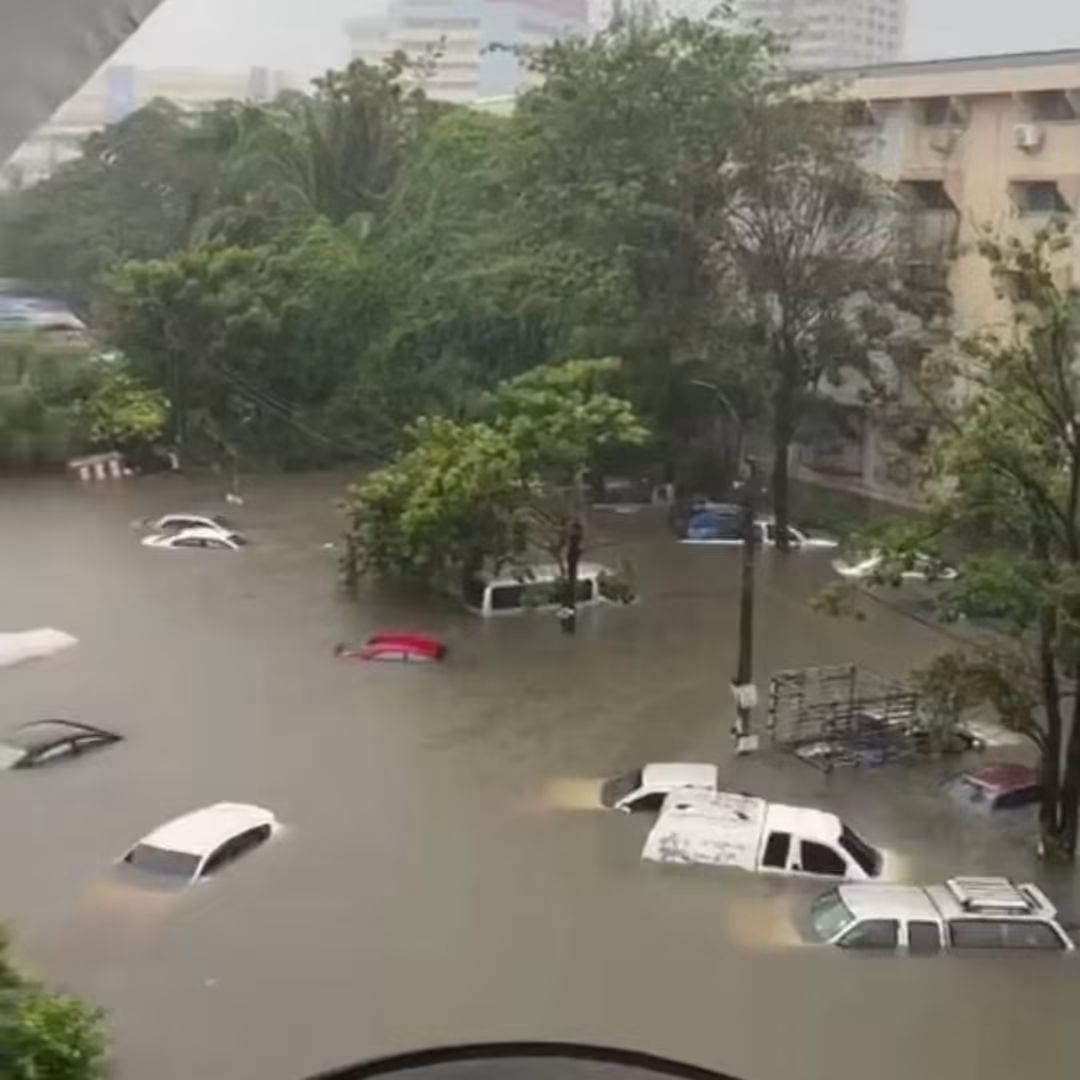
Bang Kapi — worst affected
Cars are submerged to roof level. Photographs from Saturday morning show a taxi under water to the window line and parked vehicles completely below the surface. Saen Saep Canal is full, so the streets cannot drain and the water is standing. Police say no vehicle of any type should attempt to pass. “Do not risk driving through floodwaters, to prevent engine stalling, vehicle submersion and potential hazards.”
Source: Lat Phrao Metropolitan Police Station, 26 SeptemberSukhumvit Soi 63 (Ekkamai)
Listed by City Hall as impassable for small cars.
Source: BMA, 26 SeptemberPhong Phet intersection
Listed by City Hall as impassable for small cars.
Source: BMA, 26 SeptemberCity Hall named seven locations as impassable for small cars on 26 September. Only some have been published in English so far; we add them here as they are confirmed.
Districts under closest watch
Min Buri
Eastern Bangkok. Flagged by the governor as high risk through 27 September.
Lat Krabang
Eastern Bangkok. High risk through 27 September. Suvarnabhumi Airport sits in this district — allow extra time.
Sai Mai
Northern Bangkok. High risk through 27 September.
Nong Chok
Declared a flood disaster area already on 25 September.
Suan Luang
Declared a flood disaster area already on 25 September.
Khan Na Yao
Declared a flood disaster area already on 25 September.
What the city is doing
- A cell broadcast alert has been sent to phones in Bangkok as canal levels reached critical stage. People in low-lying and canal-side areas are told to move belongings to higher ground.
- Governor Chadchart Sittipunt announced seven flood measures on 26 September, including preparing shelters and support for vulnerable residents.
- Pumping stations have been running at full capacity overnight, draining through the Phra Khanong station. Peak accumulated rainfall measured 133 mm.
- The Erawan Centre (1669) has been made medical command for the emergency, coordinating with six hospitals to move bedridden patients out of flooded homes.
- The Ministry of Commerce has ordered provincial commerce offices to monitor stocks and prices of essential goods and to report transport problems in flood-hit areas.
The weather
The Thai Meteorological Department forecast rain across 80% of central and eastern Thailand on 26 September, with heavy to very heavy rain nationally through 27 September. The system is a low-pressure area over mainland Southeast Asia combined with a strengthening southwest monsoon.
Outside Bangkok
Pattaya & Chonburi
Repeated flooding through the week. One man was swept into a canal in Nong Prue and is still missing. Sri Racha ordered more than 200 households in Nong Kham to evacuate on 25 September.
Khao Yai National Park
Closed 26–27 September after flash floods and landslide risk.
If you have to go out
- Do not drive into standing water. Most flood damage in Bangkok is engines destroyed by drivers who thought it was shallower than it was. A stalled car in a current is far more dangerous than a late arrival.
- Assume you cannot see the road. Open drain covers get lifted by the current. This is how people disappear.
- Stay away from canal edges. The kerb, the pavement and the canal all look identical under brown water.
- Watch for live electricity. Street-level wiring, signs and pumps. If water is near a pole or a shopfront, keep your distance.
- Leaving for the airport? Suvarnabhumi is in Lat Krabang, one of the worst-hit districts. Add hours, not minutes. Check with your airline before you set off.
- Motorbike taxis and delivery riders will take flooded routes if you ask them to. Do not ask them to.
Emergency numbers
- 1669Medical emergency (Erawan Centre) — English available
- 199Fire and rescue
- 1555Bangkok city hotline — flooding, blocked drains, fallen trees
- 1784Department of Disaster Prevention and Mitigation
- 1197Traffic police
- 1155Tourist Police — English available
About this page. Everything here comes from the Bangkok Metropolitan Administration, the Metropolitan Police, the Thai Meteorological Department and Thai news media. Each item is dated. We do not publish crowd-sourced flood reports as fact.
A word on the maps going around. A Thai-language road map is being shared widely, including by government social media accounts. Read its own header before you rely on it: it is a snapshot of Google Maps traffic colours taken between 09:44 and 09:50 on 26 September. Red on Google Maps means slow traffic, which is not the same as flooding, and the page says so itself. It is a useful hint, not a flood map.
Conditions change by the hour. If this page says one thing and the water in front of you says another, believe the water.
ThaiPuls · thaipuls.com